Drones With Thermal Imaging
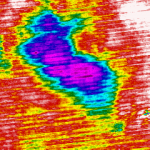
Thermal imaging is used when looking at looking at wide areas as it provides an overview of the whole site. Drones are often used for surveying roof areas to provide an indication of where there are problems.
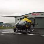
Drone surveys can be conducted from a helicopter or a drone which is a lightweight unit, Thermal imaging surveys can be an excellent way of analysing your site Aerial inspections are ideal for surveying roof areas and provide an initial indication of problems in a cost effective way.
Want To Know More About Aerial Thermography Call Us On – 020 3044 2940
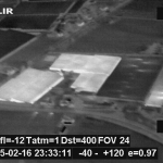
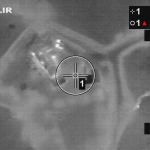
Ti have experience from looking for leaking aqueducts to leaking underground hot water pipes, herd counts and aerial flat roof inspections. We use a sophisticated system that enables us to capture full radiometric .avi files, still images, full digital video which has a GPS overlay directly onto the image showing where the images are taken at all times.
Surveys can be carried out from helicopters , Drones, or extending poles having the ability to detect:
- Underground Landfill Fires
- Water / Steam Leaks
- Large Area Heat Loss Surveys
- Flat Roof Leaks
- Heat Loss
We can also provide with you with aerial video footage which can be handy for analysing the situation or incorporating it within your own or clients portfolio providing a clear presentation or base for planning and construction projects.